
The Village of Tong, Salop
The village of Tong, Shropshire has a great deal to commend itself. This web site promotes the recent book 'Discovering Tong' that describes all about the village.
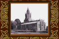
For a full account of the village, the magnificent church, its demolished castle and all its intriguing history please visit the Tong Church web site ➚ (tong-church.org.uk).
Tong is located on the Shropshire - Staffordshire county boundary north west of Birmingham, UK. Its northern boundary is Watling Street (A5), an important Roman road leading from London to Holyhead. The parish is dissected by the A41 - a major trunk road from London to Chester. Another road, now re-routed and all but forgotten is the road south to Worcester via Bridgnorth which was a highway up to the nineteenth century joining the A41 at Tong Norton.
The village, now a quiet backwater was at times in its history the home to important English dukes, barons and landowners and was visited by royalty. In its early years its eminence came from its strategic position close to the fractious Welsh border and the rich farmland that results from a rich layer of glacial marl over sandstone.
The name of Tong is most likely derived from the 'tongue' of land formed by the two streams that define the southern and western boundaries of the parish. To the east are remnants of the ancient oak woodland that provided hunting grounds - and a hiding place for King Charles II after the Battle of Worcester in 1651. To the north is Weston Park the ancient seat of the Bridgeman family (the Earls of Bradford)). By contrast just to the south is the large RAF training base at Cosford ➚ which houses an extensive aeronautical museum.

Copyright © 2007 to 2024 Discovering Tong